
.png)

April 2026 community meeting: Read and comment on comprehensive plan recommendations for Dist. 5 | The Homepage
- jmartinez5135
- May 1
- 5 min read
By Juliet Martinez, managing editor
The April 14 Greater Hazelwood community meeting took place at the Spartan Center to accommodate more people. A crowd of about 40 people showed up, plus about 20 more online. They came to hear about Pittsburgh Regional Transit’s most recent proposal and the revived effort to create a comprehensive plan for the city.
Bus line refresh
Ben Nicklow from the Pittsburgh Regional Transit service development department spoke about the changes the authority also known as PRT is proposing. Please see Page 1 for more on this presentation.
Comprehensive plan
Ivette Mongalo-Winston is the acting director of the Pittsburgh Department of City Planning. She spoke about the comprehensive plan that the city is once again working on. The plan was introduced in February 2024 with a $6 million price tag. Public meetings happened, but last November, City Council stopped spending on the plan. In mid-March, the Heinz Endowments and the Pittsburgh Foundation gave the city $750,000 to finish it. Read more on Page 6.
A comprehensive plan provides a guide for decision-making across city departments. District 5 City Councilor Barb Warwick compared it to the Greater Hazelwood Neighborhood Plan, which many in the room participated in creating.
“One thing I’ve noticed, when they come with a new project... there’s a mandate to justify that project relating to the neighborhood plan. It has been a good guide for what developments come to this neighborhood,” Ms. Warwick said.
She added that the neighborhood plan will fit into the citywide plan, not be replaced by it.
Ms. Mongalo-Winston said the process of creating the plan is about 60% complete. It is in what she called the recommendation phase. She expected to present a draft to the City Planning Commission in August. She said the consultants who started the process looked through all of the pre-existing plans and compiled the recommendations into this one. They are now seeking public input to determine whether the recommendations in those plans are still relevant.
“We need to regain the vibrancy of the city,” she said. “We need more people and jobs.”
She broke down how to do that. It involves putting more people and jobs near transit, making decisions about how climate change risk affects different areas. It means making shared amenities and services more accessible, and investing in infrastructure.
The final comprehensive plan will reflect a shared vision that centers residents’ voices, Ms. Mongalo-Winston said. It will have an existing land use map and a future land use map that will guide where and how development happens. It will also have policy recommendations that address a range of topic areas including strategies for environmental challenges. It will come with implementation strategies that make the city’s investments and operations more efficient, and finally an updatable online dashboard to track progress. This will allow the city and residents to measure progress toward the plan’s goals.
“We’re going to have implementation strategies where it names specific actions, who the partners are,” she said, adding that those include government, private sector and public sector parties, and potential funding streams.
Ms. Mongalo-Winston said the comprehensive plan is not a zoning change, though it will guide future zoning changes. It is also not a detailed plan for each neighborhood.
Land use strategies
The land use recommendations fall along a spectrum with “adapt” at one end and “transform” at the other. Land that is prone to flooding or landslides, with steep slopes are in the “adapt” category.
Next is the “sustain” category, which are places that are thriving and only need small interventions to maintain the quality of life.
“Stabilize” is focused on bedroom communities that might have vacant properties or need better transit connections.
Economic centers like Downtown and Oakland are in the “strengthen” category because there is room for higher density development there.
The “transform” category applies to riverfronts and heavy industry areas.
“We’re pivoting to using our rivers better, we are encouraging mixed-use districts,” Ms. Mongalo-Winston said. “So they’re transforming from maybe a completely industrial use to something more dynamic that the neighborhood needs.”
In a follow-up call on April 17, Ms. Mongalo-Winston addressed whether the plan was recommending cutting off funds to flood- and landslide-prone areas like Four Mile Run and parts of Hazelwood. This scenario was floated in an October comprehensive plan meeting in the Hill District and reported in The Homepage.
The current recommendations are more concerned with identifying specific at-risk parcels and supporting them with the climate-resilient infrastructure they need, Ms. Mongalo-Winston said. The city would not try to get people to move away from those areas, but new construction projects in those areas will be viewed with caution.
“It’s not a swath strategy; it’s more a surgical strategy,” she said. “We’ll be careful about building around the land and not making it worse there.”
Drivers of growth
She spoke about four factors in growth: housing, economy, mobility and resilient infrastructure. Housing is focused on where and what kinds of residential changes happen, including single-family to multiplexes and apartment buildings. Economy is focused on where the jobs and industries are. Mobility asks how people and goods move and connect to opportunities. Mobility focuses on public transit, trails, cars and waterways. Resilient infrastructure asks how infrastructure, environmental systems and open space support safe and livable communities. It focuses on parks, waste, stormwater and energy.
A participant asked whether the recommendations are addressing infrastructure like sidewalks that are often in bad condition. Ms. Mongalo-Winston said her department is working with Ms. Warwick on making sidewalk management a higher priority in the near term. For the future, her department is researching different ways of making sure sidewalks are maintained.
“We’re looking at trying some new tools and policies to fix some long-standing problems,” she said.
Participants at the meeting were encouraged to comment on the recommendations for District 5 listed below.
Economy
Hazelwood Green: Allow mixed-use and emerging sectors like clean energy construction and manufacturing.
Second Avenue: Fill gaps and promote development along the high-vacancy corridor, revitalizing the business district with cultural and ethnic business identities, including a grocery store.
Greenfield Avenue, Murray Avenue and The Waterfront: Support existing businesses while allowing greater flexibility in uses; make it easier to repurpose storefronts that no longer support commercial activity, keep corridors active as they evolve.
Murray and Forbes avenues: Grow and diversify commercial opportunities while actively protecting the businesses and assets that define these corridors.
Housing
All areas: Make it easier to build more types of homes (duplexes, triplexes, etc.) and invest in maintaining existing housing.
Hazelwood Green: Support multi-family moderate- to high-density and mixed-use development; complete existing development plan.
Hazelwood: Bring back low- to moderate-density housing and a mix of housing types.
Squirrel Hill South: Grow along key transit corridors with more low- to moderate-density variety and affordable options.
Greenfield, Swisshelm Park, Hazelwood and Glen Hazel: Promote gradual growth, more housing variety and affordable options while retaining housing scale.
Landslide-prone areas: Reduce risk, invest in infrastructure, stabilize housing and support adaptations; limit new residential density, transition to open space.
Mobility
Strengthen frequent transit routes by investing in high-performing transit corridors and expanding multi-modal options.
Support transit-oriented job and housing growth.
Expand and improve bike facilities in alignment with the Bike + Plan, prioritizing areas with poor access.
Expand PoGoH stations and create mobility hubs where transit, micromobility and other services come together to make transfers simple and reliable.
Improve sidewalk and stair conditions, especially where needed to access existing transit and commercial streets.
Resilient infrastructure
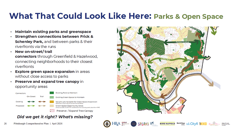
Maintain existing parks and green spaces.
Strengthen connections between Frick and Schenley parks, and between parks and riverfronts via the runs.
Create new on-street/trail connectors through Greenfield and Hazelwood, connecting neighborhoods to their closest riverfronts.
Explore green space expansion in areas without close access to parks.
Preserve and expand tree canopy in opportunity areas.
To comment online, visit pgh2050.com.


Comments